
- Retrait gratuit dans votre magasin Club
- 7.000.000 titres dans notre catalogue
- Payer en toute sécurité
- Toujours un magasin près de chez vous
- Retrait gratuit dans votre magasin Club
- 7.000.0000 titres dans notre catalogue
- Payer en toute sécurité
- Toujours un magasin près de chez vous


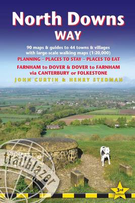
North Downs Way
British Walking Guide: Farnham-Dover-Farnham - 90 Large-Scale Walking Maps (1:20,000) & Guides to 44 Towns & Villages - Planning, Places to Stay, Places to Eat
Henry Stedman, John Curtin
21,50 €
+ 43 points
Description
The North Downs Way is a 131.6-mile (211.6km) National Trail that runs from Farnham in Surrey to Dover in Kent, partly following the old Pilgrims' Way to the shrine of St Thomas à Becket at Canterbury. It winds through the protected landscape of the Surrey Hills and the Kent Downs passing medieval churches, castles, Neolithic burial sites, vineyards and numerous WWII defences. There are literary associations with Swift, Cobbett, Charles Dickens and Jane Austen. It's not a difficult walk, with few steep ascents or descents. An alternative route runs via Folkestone. All-in-one hiking route guide, maps and accommodations. Includes 90 large-scale walking maps (3 1/8 inches to 1 mile); 12 town maps and 10 stage maps. Full details of all accommodations and campsites, restaurants and pubs; plus full public transport information. Includes day-walks.
- Booking & Getting to the UK - information for US travelers
- 112 Maps: 90 large-scale walking maps - 1:20,000 (3-1/8 inches to 1 mile), 12 town plans, 10 stage maps with trail profiles showing hills and descents, and 2 overview maps.
- Detailed accommodations with reviews: B&Bs, campsites, pubs, hotels, bunkhouses.
- Where to eat with reviews: cafes, teashops, pubs, takeaways and restaurants.
- Comprehensive public transport information with frequency of services for all access points on the Path.
- Downloadable GPS waypoints with what3words references.
- Itineraries for all walkers, whether hiking the entire route or sampling highlights on day walks, weekends or short breaks.
- Unique mapping features - walking times, directions, tricky junctions, places to stay, places to eat, points of interest written onto the maps.
- Flora and fauna - four page full color flower guide, plus an illustrated section on local wildlife
- Green hiking - understanding the local environment and minimizing our impact on it.
- Now rewritten as a two-way guide for walking from Farnham to Dover and Dover to Farnham on both the route via Canterbury and the alternative route via Folkestone.
Spécifications
Parties prenantes
- Auteur(s) :
- Editeur:
Contenu
- Nombre de pages :
- 216
- Langue:
- Anglais
- Collection :
Caractéristiques
- EAN:
- 9781912716500
- Date de parution :
- 04-11-25
- Format:
- Livre broché
- Format numérique:
- Trade paperback (VS)
- Dimensions :
- 120 mm x 180 mm
- Poids :
- 127 g


Les avis
Nous publions uniquement les avis qui respectent les conditions requises. Consultez nos conditions pour les avis.