
- Retrait gratuit dans votre magasin Club
- 7.000.000 titres dans notre catalogue
- Payer en toute sécurité
- Toujours un magasin près de chez vous
- Retrait gratuit dans votre magasin Club
- 7.000.0000 titres dans notre catalogue
- Payer en toute sécurité
- Toujours un magasin près de chez vous


Description
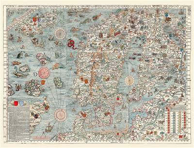
Carta Marina
Réalisée par le cartographe suédois Olaus Magnus, archevêque d'Uppsala, financée par Gerolamo Querini (patriarche de venise entre 1524 et 1554), et dédiée au pape Paul III (Alexandre Farnèse, 1534-1549), cette immense « Carte marine et description des terres du nord et des merveilles qu'elles contiennent, soigneusement dressées en 1539 À Venise grâce à la générosité du révérend Jérôme Quirinus » représente magnifiquement, quoique avec une certaine approximation, les côtes et les terres encerclant la mer Baltique, le nord de l'Écosse, l'Islande, les îles Orcades, Hébrides, Shetland, Féroé, un bout du Groenland... et même la légendaire île de Thulé.
Carta Marina
Made by the Swedish cartographer Olaus Magnus, Archbishop of Uppsala, financed by Gerolamo Querini (Patriarch of Venice between 1524 and 1554), and dedicated to pope Paul III (Alexander Farnese, 1534-1549), this immense « Nautical chart and description of the northern lands and the wonders they contain, carefully drawn up in 1539 in Venice thanks to the generosity of the Reverend Jerome Quirinus » magnificently represents, although with a certain approximation, the coasts and lands surrounding the Baltic Sea, the north of Scotland, Iceland, the Orkney Islands, the Hebrides, the Shetlands, the Faeroe Islands, a bit of Greenland... and even the legendary island of Thule.
Spécifications
Parties prenantes
- Auteur(s) :
- Editeur:
Contenu
- Langue:
- Français
Caractéristiques
- EAN:
- 9782380362381
- Date de parution :
- 28-05-25
- Format:
- Coffret
- Dimensions :
- 190 mm x 340 mm
- Poids :
- 104 g

Les avis
Nous publions uniquement les avis qui respectent les conditions requises. Consultez nos conditions pour les avis.