
- Retrait gratuit dans votre magasin Club
- 7.000.000 titres dans notre catalogue
- Payer en toute sécurité
- Toujours un magasin près de chez vous
- Retrait gratuit dans votre magasin Club
- 7.000.0000 titres dans notre catalogue
- Payer en toute sécurité
- Toujours un magasin près de chez vous


Description
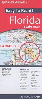
Rand McNally's Easy To Read State Folded Map is a must-have for anyone traveling in and around Florida, offering unbeatable accuracy and reliability at a great price. Our trusted cartography shows all Interstate, U.S., state, and county highways, along with clearly indicated parks, points of interest, airports, county boundaries, and streets.
The easy-to-use legend and detailed index make for quick and easy location of destinations. You'll see why Rand McNally folded maps have been the trusted standard for years.
Regularly updated, full-color maps
Larger map with a bigger type size than the Rand McNally Folded Map
Clearly labeled Interstate, U.S., state, and county highways
Indications of parks, points of interest, airports, county boundaries, and more
Mileage and driving times map
Detailed index
Convenient folded size
Coverage Area
Detailed maps of: Daytona Beach, Fort Myers/Cape Coral, Gainesville, Jacksonville, Key West, Downtown Key West, Lakeland/Winter Haven, Melbourne/Titusville, Miami & Vicinity, Downtown Miami & Miami Beach, Naples, Orlando, Pensacola, St. Augustine, Tallahassee
Product Details: Florida State
Dimensions (unfolded): 28" x 40".
Spécifications
Parties prenantes
- Editeur:
Contenu
- Langue:
- Anglais
- Collection :
Caractéristiques
- EAN:
- 9780528881176
- Date de parution :
- 01-03-10
- Format:
- Carte pliée
- Dimensions :
- 160 mm x 235 mm
- Poids :
- 54 g
Les avis
Nous publions uniquement les avis qui respectent les conditions requises. Consultez nos conditions pour les avis.