- Retrait gratuit dans votre magasin Club
- 7.000.000 titres dans notre catalogue
- Payer en toute sécurité
- Toujours un magasin près de chez vous
- Retrait gratuit dans votre magasin Club
- 7.000.000 titres dans notre catalogue
- Payer en toute sécurité
- Toujours un magasin près de chez vous


Description
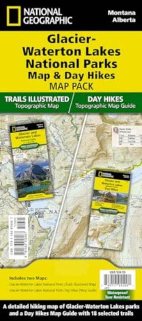
- Waterproof - Tear-Resistant - Topographic Maps
Together, Glacier National Park in the United States and Waterton Lakes National Park in Canada hold the honor of being the world's first international peace park. This two title Map Pack Bundle helps explorers of all levels see everything these astounding parks have to offer. The map pack includes an overview map that shows the entire park as well as a Day Hikes map guide. With this combination of maps visitors can feel comfortable planning a trip to a park with options for everyone, from multi-day backpack trips to short hikes on the shores of Saint Mary Lake.
The Glacier and Waterton Lakes National Park Day Hikes Topographic Map Guide includes eighteen diverse hikes for all hiking enthusiasts, the hikes range in difficulty and distance to help hikers select the best trail for their timing, abilities, and location within the parks. Each hike has a detailed map, a trail profile visualizing the changes in elevation, and a short summary of the interesting features encountered along the trip.
The Glacier and Waterton Lakes Day Hikes and National Parks Map Pack includes:
- Map 215:: Glacier and Waterton Lakes National Parks
- Map 1708:: Glacier and Waterton Lakes National Parks Day Hikes
Every Trails Illustrated map is printed on "Backcountry Tough" waterproof, tear-resistant paper. A full UTM grid is printed on the map to aid with GPS navigation.
- Sheet Size = 25.5" x 37.75"
- Folded Size = 4.25" x 9.25"
Spécifications
Parties prenantes
- Auteur(s) :
- Editeur:
Contenu
- Nombre de pages :
- 50
- Langue:
- Anglais
- Collection :
Caractéristiques
- EAN:
- 9781566958967
- Date de parution :
- 26-10-22
- Format:
- Carte pliée
- Dimensions :
- 108 mm x 235 mm
- Poids :
- 167 g