Suite à une grève chez bpost il n'est temporairement pas possible de choisir pour livraison à domicile ou à une autre adresse. Besoin de quelque chose en urgence ? Choissisez pour retrait en magasin ou passez plutôt dans un magasin Club à proximité.
- Retrait gratuit dans votre magasin Club
- 7.000.000 titres dans notre catalogue
- Payer en toute sécurité
- Toujours un magasin près de chez vous
Suite à une grève chez bpost il n'est temporairement pas possible de choisir pour livraison à domicile ou à une autre adresse. Besoin de quelque chose en urgence ? Choissisez pour retrait en magasin ou passez plutôt dans un magasin Club à proximité.
- Retrait gratuit dans votre magasin Club
- 7.000.0000 titres dans notre catalogue
- Payer en toute sécurité
- Toujours un magasin près de chez vous


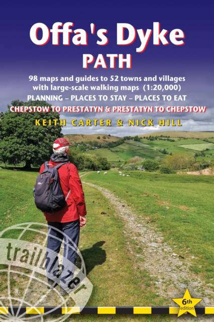
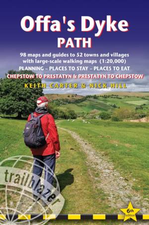
Offa's Dyke Path
British Walking Guide: Planning, Places to Stay, Places to Eat; Includes 98 Large-Scale Walking Maps
Keith Carter, Nick Hill
19,95 €
+ 39 points
Format
Description
The Offa's Dyke Path is a superb national trail that runs from the North Wales coast to the Severn Estuary following the line of Offa's Dyke, an impressive 8th century earthwork along the English/Welsh border. The ever-changing landscape - the Clwydian Range, the Shropshire Hills, the Black Mountains and the Wye Valley - is steeped in history and legend providing 177 miles of fascinating walking.
This is an all-in-one two-way hiking route guide, maps and accommodations for the 177-mile Offa's Dyke Path in Wales, which runs along the border with England. Includes 87 large-scale walking maps (3 1/8 inches to 1 mile); 11 town maps and 15 overview maps. Full details of all accommodations and campsites, restaurants and pubs; plus full public transport information. Includes day-walks.
- Two-way guide - walk from north to south (Prestatyn to Chepstow) or south to north (Chepstow to Prestatyn)
- 11 town plans and 87 large-scale walking maps - at just under 1:20,000 - showing route times, places to stay, points of interest and much more
- Plus 14 overview maps Itineraries for all walkers - whether walking the route in its entirety over seven to eight days or sampling the highlights on day walks and short breaks
- Practical information for all budgets - camping, bunkhouses, hostels, B&Bs, pubs and hotels - where to stay, where to eat, what to see, plus detailed street plans
- Comprehensive public transport information - for all access points on the path.
- Flora and fauna - four page flower guide, plus an illustrated section on local wildlife
- Green hiking - understanding the local environment and minimizing our impact on it
- With downloadable gps waypoints now also with what3words references
- Includes extra colour sections: 16pp colour introduction and 16pp of colour mapping for stage sections (one stage per page) with trail profiles.
Spécifications
Parties prenantes
- Auteur(s) :
- Editeur:
Contenu
- Nombre de pages :
- 256
- Langue:
- Anglais
- Collection :
Caractéristiques
- EAN:
- 9781912716425
- Date de parution :
- 08-10-24
- Format:
- Livre broché
- Format numérique:
- Trade paperback (VS)
- Dimensions :
- 121 mm x 178 mm