- Retrait gratuit dans votre magasin Club
- 7.000.000 titres dans notre catalogue
- Payer en toute sécurité
- Toujours un magasin près de chez vous
- Retrait gratuit dans votre magasin Club
- 7.000.000 titres dans notre catalogue
- Payer en toute sécurité
- Toujours un magasin près de chez vous


Description
- Waterproof - Tear-Resistant - Topographic Map
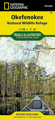
Covering 630 square miles in southeast Georgia, the Okefenokee National Wildlife Refuge encompasses nearly all of the world-renowned Okefenokee Swamp. Expertly researched and created in partnership with local land management agencies, National Geographic's Trails Illustrated map of Okefenokee National Wildlife Refuge provides an unparalleled tool for exploring this magnificent wetland. This map offers unmatched detail of the entire park and features key areas of interest including Stephen C. Foster State Park; Suwannee River Sill Recreation Area; Okefenokee Swamp Park; Kingfisher Landing; and Laura S. Walker State Park.
Designed with a wide range of visitors in mind, this map features detailed topography with shaded relief and vegetation classification; accurate road network including Okefenokee Trail and Swamp Island Drive auto tours; visitor centers and facilities; safety tips; and agency contact information. Paddling is the best way to explore the refuge in depth, and this map is loaded with information specific to that activity including color-coded canoe trails, trail mileage, difficulty ratings, and charts of canoe trails and overnight canoe trips. Many recreation features are noted as well, including campgrounds, boat ramps, shooting ranges, and areas for wildlife viewing, water skiing, biking, paddling, fishing, and swimming.
Every Trails Illustrated map is printed on "Backcountry Tough" waterproof, tear-resistant paper. A full UTM grid is printed on the map to aid with GPS navigation.
Other features found on this map include: Okefenokee Swamp.
- Map Scale = 1:63,360
- Sheet Size = 37.75" x 25.5"
- Folded Size = 4.25" x 9.25"
Spécifications
Parties prenantes
- Auteur(s) :
- Editeur:
Contenu
- Nombre de pages :
- 2
- Langue:
- Anglais
- Collection :
Caractéristiques
- EAN:
- 9781566956277
- Date de parution :
- 01-01-13
- Format:
- Carte pliée
- Format numérique:
- Gelamineerd
- Dimensions :
- 10 cm x 19 cm
- Poids :
- 91 g